
 Български
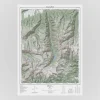


Pirin mountain poster map
65,00 лв. (33,23 €)
Pirin – a symbol of Bulgaria’s alpine beauty, home to the country’s second-highest peak, Vihren (2,914 m), and more than 180 glacial lakes.
❤️ This product has a social mission – part of the proceeds are donated to the Bulgarian Mountain Rescue Service (MRS).
➡️ The poster is perfect as decoration or as a gift for mountain lovers, as well as enthusiasts of design and cartography.
Size: 50 × 70 cm
Paper: 170 g matte
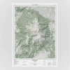
The frame (RODALM) is shown for illustrative purposes only.
5 in stock
Pirin – a symbol of Bulgaria’s alpine beauty, home to the country’s second-highest peak, Vihren (2,914 m), and more than 180 glacial lakes.
❤️ This product has a social mission – part of the proceeds are donated to the Bulgarian Mountain Rescue Service (MRS).
➡️ The poster is perfect as decoration or as a gift for mountain lovers, as well as enthusiasts of design and cartography.
Size: 50 × 70 cm
Paper: 170 g matte
The frame (RODALM) is shown for illustrative purposes only.
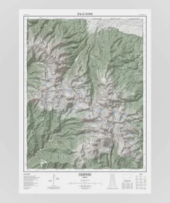
The map is at a 1:40,000 scale, where 1 cm on the map corresponds to 400 meters in reality. It features contour lines at 10-meter intervals, with shaded relief illuminated from 315° (northwest) at a 45° sun angle. Terrain, peaks, hiking trails, huts, shelters, lakes, and rivers are depicted in a way that enables quick orientation and a clear understanding of the landscape.
The map allows orientation using:
A geographic coordinate grid (latitude/longitude) with divisions every 1 arc minute, labeled every 3 minutes, with each minute subdivided into 12 arc seconds;
A Universal Transverse Mercator (UTM) grid with 1,000-meter spacing, superimposed on the terrain.
Additional elements include:
Legend;
List of the ten highest peaks;
Scale bar;
Slope diagram for calculating the average slope of a selected segment;
Diagram showing true north, magnetic declination and the deviation of the UTM grid from true north.
The map deliberately includes only carefully selected cartographic elements to achieve clarity and focus.
📚 With every order, you’ll also receive our detailed digital guide to help you interpret every element of this map.
| Weight | 0,2 kg |
|---|---|
| Dimensions | 50 × 7 × 7 cm |
Only logged in customers who have purchased this product may leave a review.
Related products


Reviews
There are no reviews yet.